Washington DC — The NASA-ISRO Synthetic Aperture Radar (NISAR) satellite has released its first radar images of Earth’s surface, offering unprecedented detail of landscapes across the United States. The joint mission between NASA and the Indian Space Research Organisation (ISRO) marks a major milestone in global Earth observation efforts, combining advanced radar technologies to monitor environmental changes with high precision.
Launched by ISRO on July 30, 2025, NISAR is the world’s first satellite equipped with dual radar systems — NASA’s L-band and ISRO’s S-band — enabling it to scan Earth’s land and ice surfaces every 12 days. The satellite was raised into its operational 747-kilometre orbit in mid-September and is currently in its commissioning phase, with full science operations scheduled to begin in November.
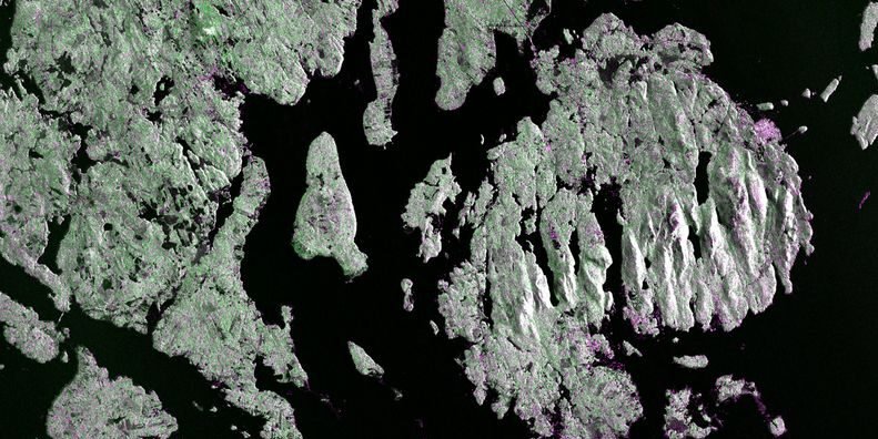
The first test images, captured in late August, showcase the satellite’s ability to distinguish between various land cover types. On August 21, NISAR’s L-band radar imaged Mount Desert Island off the coast of Maine, revealing narrow waterways, dense forest cover, and islets surrounding the island. Magenta tones in the image indicate built environments such as the town of Bar Harbor, while green areas represent vegetation and dark regions depict water bodies.
Two days later, on August 23, the satellite captured northeastern North Dakota, highlighting wetlands along the Forest River and adjacent croplands. The radar data revealed circular patterns from center-pivot irrigation systems, fallow fields, and patches of soybean and corn crops. These images demonstrate NISAR’s ability to monitor seasonal changes, land use, and ecological health with remarkable clarity.
NISAR’s 25-centimeter wavelength allows it to penetrate forest canopies, measure soil moisture, and detect minute land movements — capabilities critical for tracking natural disasters such as floods, landslides, and earthquakes. The satellite’s data will also support climate change research, agricultural monitoring, and infrastructure planning worldwide.
“This is just a preview of the hard-hitting science that NISAR will produce,” said Nicky Fox, Associate Administrator of NASA’s Science Mission Directorate. “We will be able to monitor Earth’s changing land and ice surfaces in unprecedented detail, equipping decision-makers to respond to natural disasters and other challenges”.
The successful release of these initial images underscores the strength of international collaboration in space science and sets the stage for transformative insights into Earth’s dynamic systems.